
Katahdin got its own story earlier.


This is the 100 Mile Wilderness — 100 miles of bog bridges, river fords, wild blueberries, and deer flies that bite through wool socks. We started NOBO on July 5th, my 58th birthday, with 10 days of food on our backs. By the time we were on day 3, Marty had his trail name– Daddy Longlegs. The 100 mile wilderness has some rock scrambling and BIG steps. He would bee-bop across or up an obstacle and I would ask, “How on earth did you do that?” He would point to where he stepped and I would reply, “My legs are not that long!” After a few days of this, I said, “I am not a Daddy Longlegs like you!” and poof…. he got his trail name. It absolutely fits him!


We Prepared For A Year.
We tested everything on multiple backpack trips prior. The 1-pound 11 ounce chair was determined to be a keeper during this time. We ended up being very grateful we carried the chairs with us! We did so many gear shakedowns that we were 100 percent certain we had all the right gear. It turns out that we were absolutely right!
We started the drive to Maine July 2nd after work. We ended up making it to Bangor late on July 3rd. We went into Monson on July 4th. We went to the AT Visitor Center where they gave us the ford list and made sure we knew how to cross Big Wilson Stream, Long Pond Stream, West Branch Pleasant River, East Branch Pleasant River, plus Little Wilson, Vaughn, Pollywog, Rainbow, Cooper Brook, and a dozen unnamed shin-deep crossings. They let us know that the river levels were all okay for crossing along the 100 Mile Wilderness. We found the trailhead so that Sunday morning we could get on trail bright and early without getting lost. Ha ha Not really lost, we just wanted to know where it was, as we wanted to get on trail without delay.


I also solved my biggest fear at Shaw’s Hiker Hostel on the 4th— snacks. Ten days of food Lin my backpack left little to no room for many snacks. I found a LiteAF fanny pack in the same groovy blooms pattern as my backpack there at Poet’s Gear Emporium. It was a sign! We ran by Dollar General to get snacks for my new fanny pack and my trail name was updated. Trail name: Snacky Turtle. Now officially equipped!
If you look to the right, you’ll see the ultralight fanny pack! It turned out to work perfectly. My LiteAF backpack has pockets on the straps, but I do not have hip belt pockets. They have not worked well for me on other backpacks, so I was not worried about not having them.
I kept a few first aid supplies, lip balm and snacks in this fanny pack. When a SOBO hiker passed us needing some Tylenol or Ibuprofen, I was able to hand her some from the fanny pack. She had fallen and was in a bit of pain. She said, “If it isn’t packed too far into your pack, would you mind?” I said, “No trouble at all! I have some right here.” They were still in their original packaging, which probably made her feel better about taking them. But…..I am getting ahead of myself. Back to the beginning.
The Plan Meets Reality

We went to a seafood joint in Bangor on the night of the 4th. Lobster and seafood boil. Marty got sick the night of July 4th, but he felt better on the 5th, so we started anyway. Three miles in, my stomach revolted. Multiple times. We still made nearly 7 miles that first day before I spiked a low fever and chills. That’s when we put it together, we must have food poisoning from the food we both ate. UGH. It was awful.

Day 2 was 6.3 miles. Brutal. I told Marty that I needed to get off trail to recover a bit before going any further. We made it to a campsite and set up camp. It is all I could do to complete 6.3 miles. I sat and rested as best I could with the biting flies swarming. We even put our chairs inside the tent without the fly to give us some relief from those damn flies!

The flies –I have to give them their own paragraph. The deer flies in Maine are not like anything we have ever seen!. They are insanely, aggressively relentless. They bite through knee-high wool socks. They bit through two layers of clothing. Through shirts. Natural repellent did nothing. Bug spray and head nets or you suffer!! They bit through everything, man! I had to use a neck gaiter on my hair to keep them from trying to “nest” in my hair. It was absolutely crazy making. Yes, they bit right through all of my hair, too. Horrible creatures.
Day 3, July 7th, we took a Nero day. Not a Zero. A Nero — near-zero. Four miles . We got into Monson where we had cell service and got a local AirBnB. It was a little place with 4 hotel rooms called Abbot Trailside Lodging. It was simple, clean, next to ATV trails, not the AT. We went to a Walgreens and I bought a neck gaiter. We also purchased Sawyer Picaridin bug spray at Shaw’s before heading to our room. The Picaridin is preferable to Deet as it doesn’t melt plastic or ruin backpacking gear.

Once we got to our room, we ate our own camp meals and looked at each other and said — we have the best meals on trail. We’d seen the resupply in Monson and KNEW we were eating well on trail. As we had been on trail 2 1/2 days at this point, we washed our clothes in the bathtub and hung them to dry. We figured we would be out there another 6 days, so we might as well go ahead and wash them.
We rested, washed, and by the next morning, I felt better. The lesson we learned that night: maybe don’t do a seafood boil right before a 100-mile trek. We had to adjust our plans slightly due to the backtracking on trail and taking up a day and a half to get off trail. The next day, we were able to get to Jo-Mary Road and get back on trail there. With just under 50 miles of the 100 mile wilderness left, we felt confident that we could get through it.
What The Pictures Can’t Catch
Pictures cannot do God’s creation justice. God’s creation is hard to catch with a lens. But here’s what we lived:

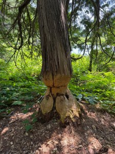
Sunrises over ponds where we ate breakfast. Sunsets that turned the bogs pink. Wild blueberries on a ridge. Mushrooms everywhere. Waterfalls where we filtered water. Lilies in bogs and ponds. Frogs, snakes, beaver dams. Trees with fresh chew marks and trees halfway felled. Lunches by lakes where we just sat and didn’t talk. God’s beauty is amazing.
Wednesday, July 8th, we made it to Pemadumcook Lake and were able to see Katahdin in the distance. We were 40 trail miles from Katahdin on that Wednesday and excited to see the view of Katahdin! To see mama K you have to take a small side trail to the lake, step on a couple of boulders and there she is in the distance. We had clear skies and could see for miles.

On Thursday, July 9th, we made it to Nesuntabunt Mountain. 35 trail miles from Katahdin, 16 nautical miles. It is one of 3 or 4 places in the wilderness that there is cell signal. Since Marty’s dad had surgery that day, we were able to call him while we ate lunch at looked at Katahdin. After lunch, we continued on for another 8 or so miles that day before setting up camp. We ended with another 12.5 mile day.

On Friday, the 10th, we did another 12.5 mile day. We used the Garmin Montana to set up a shuttle for Sunday morning when we planned to arrive at Abol Bridge. We walked over Rainbow Ledges and saw Katahdin. 21.2 trail miles from the summit of Katahdin (Baxter Peak). It was a beautiful view. It was amazing to watch the large mountain grow closer as we hiked. We continued hiking and looking for a campsite.
It was hard to find a campsite on this particular evening. We finally found one and it left us only 5.6 miles to get to the lean-to we wanted to reach the following day. This was perfect because it would get us close enough to Abol bridge that it would give us time to get the car, get resupplied and back to our tent at Abol Bridge campground before summiting Katahdin the next day.


On Saturday, we hiked 5.6 miles to the only shelter we camped at on the whole trail. We stayed overnight at Hurd Brook Lean-to. This gave us only 3.6 miles to hike to Abol Bridge on Sunday morning. Easy peasy.
We prefer stealth camping to camping at shelters. Too many people end up at the shelters. They are noisy, too. Maybe they are not always noisy– but on this night it was busy and somewhat loud. There were also mice in the privy because foolish folks left trash and food inside.
On Sunday, July 12th we came out of the Wilderness at Abol bridge around 9 am. From the bridge, it is 15.2 trail miles to the summit! Once we made it to Abol bridge, we got a shuttle to our car. Then we went into Millinocket for resupply before Katahdin. One of my trekking poles had snapped in the Wilderness — Marty gave me one of his to use— but, I needed a replacement. He told me he thought I needed two trekking poles more than he did. <laughter>. I wanted to make sure we both had two trekking poles for Katahdin because of the difficulty of the climb. So we went to the one hiker hostel and gear shop in town.


We also got a non-freeze-dried meal to carry for summit day, as well. Packets of tuna. Yum. Maybe not the perfect lunch, but it doesn’t require rehydration. We also had time to go to the Baxter State Park Visitors Center to ask about permits. Once we got to the campground, we were able to shower! Abol Bridge Campground has showers! After 5 days, we were excited to get a shower, even if we crawled back into the tent to sleep that night. The shower felt amazing!
The Most Interesting People We Met
By far the most interesting folks we met in the 100 Mile Wilderness were an Amish father and his teenage son.
Dress shirts, pants, work boots, backpacks. They wore traditional Amish clothing.
They were section hikers who had only the 100 Mile Wilderness and Katahdin left to finish all 2,196 miles of the AT. We saw them on two different days. One morning toward the end, they passed our campsite. We said hello, talked for a minute.


The father said, “We are ready to get home so we can eat real food.” I don’t know why, but this statement made me smile.
In work boots. After nearly 2,200 miles. I think about them a lot since we got off trail. We did not see them at the summit, and I wonder how hard it was to climb in work boots! I have no doubt they made it. This was their last section to complete the AT.
Coming Out
That photo — Katahdin from just outside the Wilderness at Abol bridge — is where this story stops and the next one starts.
We came out mosquito and fly-bitten, 10 days of food lighter, and ready to summit Katahdin!

Ghost and Why He Stayed Home

A lot of people asked why we did not bring Ghost. It bears repeating — Ghost is an incredible backpacker. But dogs aren’t allowed in Baxter State Park. Before we ever left for Maine, we kept hearing about rough terrain causing paw injuries, plus the insects were awful. The biting flies would have eaten him alive and likely would have caused infection. He would have gone crazy trying to catch the flies, as well! He goes crazy if he sees a housefly here at home! And…….we would never trust someone we didn’t know to watch him while we summited. In the end, we were really glad we had chosen to keep him home.

Maine has a beautiful wilderness. We did not see any bears or moose. We did see lots of moose poop and a few snakes. We kept hoping for a mossy sighting. It was crazy how much moose poop we kept finding! We found it near bogs, we found it on Rainbow Ledges and all along the trail.

 My Little Red Bike